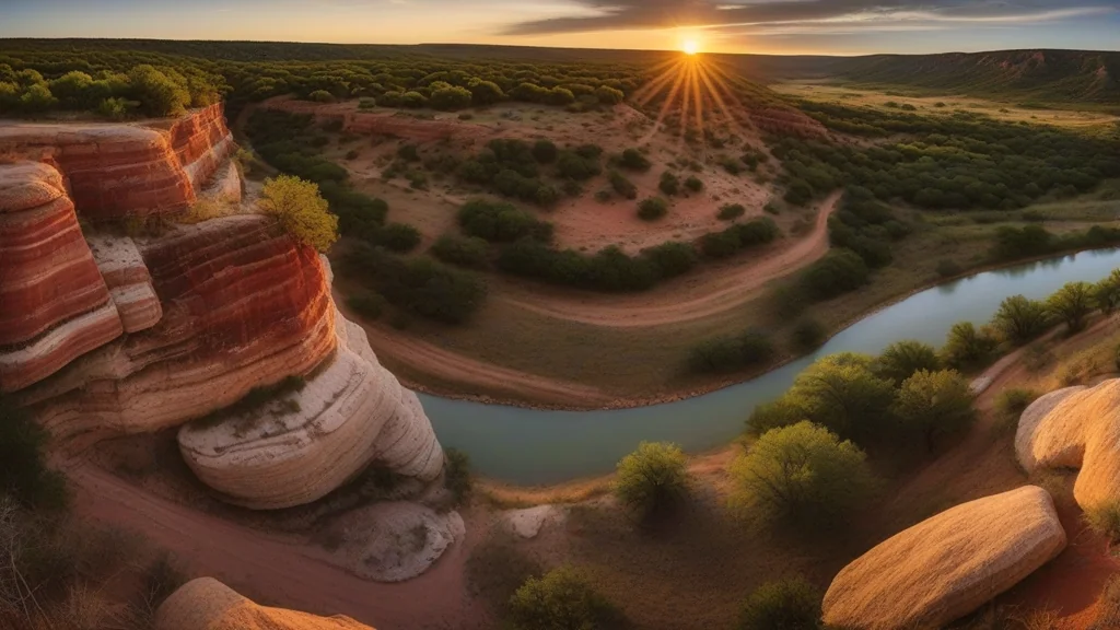
The Edwards Plateau rises from the surrounding lowlands like a great limestone table, its edges carved into the rolling hills and spring-fed creeks that give the Texas Hill Country its name. This 24-million-acre ecoregion stretches from the Balcones Escarpment west of Austin to the Pecos River canyon country, encompassing some of Texas’s most beloved landscapes—and some of its most endangered species.
If you’ve ever wandered the wildflower-covered hillsides of Enchanted Rock, kayaked the crystal-clear waters of the Guadalupe River, or watched the sun set over miles of juniper-dotted rangeland, you’ve experienced the Edwards Plateau. This is the Texas of postcards and wine trails, but also a region of surprising ecological complexity hiding beneath its scenic surface.
In this comprehensive guide, you’ll discover:
- The unique geology and climate that defines the Edwards Plateau
- Native plants from ancient oaks to spring wildflowers
- Wildlife you’ll encounter, from endangered warblers to abundant deer
- Best parks, caves, and natural areas to explore
- Conservation challenges threatening this iconic landscape
Whether you’re planning a Hill Country road trip, hoping to spot rare songbirds, or simply curious about what makes this region ecologically unique, this is your complete guide to the Edwards Plateau ecoregion.

What Is the Edwards Plateau Ecoregion?
The Edwards Plateau is a vast limestone uplift covering approximately 24 million acres of central Texas—roughly the size of Indiana. This ecoregion extends from the dramatic Balcones Escarpment (the geological fault line that runs through Austin and San Antonio) westward to the Pecos River, and from the Red Rolling Plains in the north to the South Texas Plains.
What most people call the “Texas Hill Country” is actually the eastern, dissected portion of the Edwards Plateau, where millions of years of erosion have carved the relatively flat plateau into the picturesque hills and valleys that draw millions of visitors each year. The western portions remain as broad, flat mesas and tablelands.
The ecoregion is bounded by:
- North: Rolling Plains and Cross Timbers
- East: Blackland Prairie (along the Balcones Escarpment)
- South: South Texas Plains
- West: Trans-Pecos (Pecos River)
KEY TAKEAWAY: The Edwards Plateau sits atop one of the most important aquifers in North America—the Edwards Aquifer. This underground reservoir supplies drinking water to over 2 million people and feeds the famous springs at San Marcos, New Braunfels, and Austin that support unique aquatic ecosystems found nowhere else on Earth.
The name “Edwards Plateau” honors Haden Edwards, an early Texas colonist, though the name has been applied to the geological formation since the late 1800s. Geologically, the plateau consists of Cretaceous-age limestone deposited when this region lay beneath a shallow tropical sea approximately 100 million years ago.
Geography and Climate of the Edwards Plateau
Landforms and Terrain
The Edwards Plateau is defined by its limestone foundation. This ancient seabed, uplifted and exposed over millions of years, creates a landscape unlike any other in Texas.
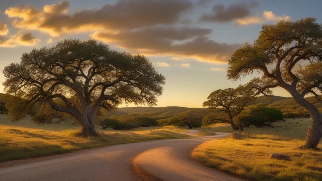
The eastern Hill Country features deeply dissected terrain where the plateau has eroded into the rolling hills, steep canyons, and spring-fed valleys that give the region its character. Elevations change rapidly—you might climb 500 feet in just a few miles of winding road between Kerrville and Fredericksburg.
Major landform features include:
- Balcones Escarpment: The dramatic fault line marking the eastern edge
- Hill Country: Dissected eastern plateau with rolling terrain
- Llano Uplift: Ancient granite dome exposed near Enchanted Rock
- Plateau Grasslands: Flat western tablelands
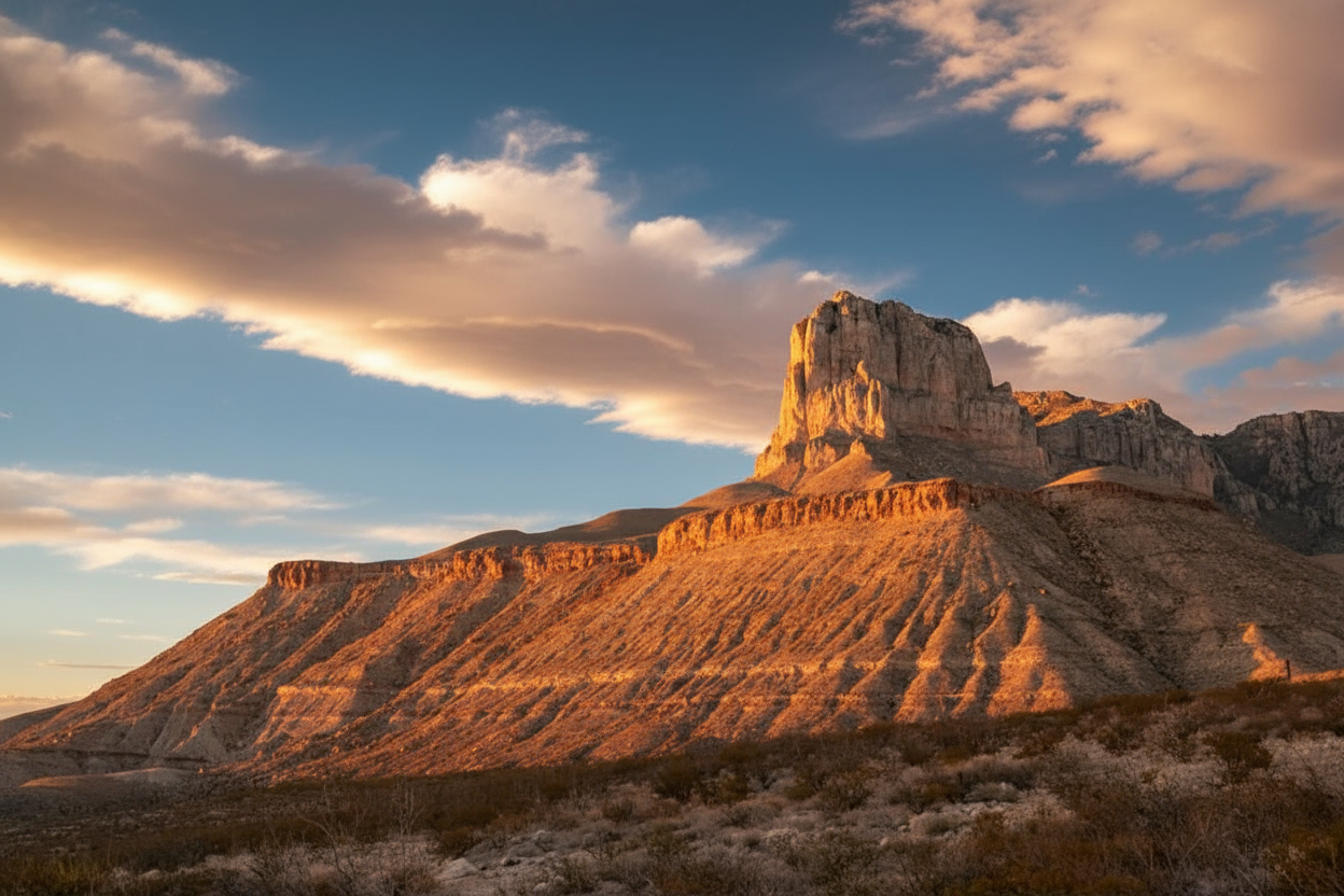
- Canyon Lands: Deep river-carved gorges in the west
- Karst Features: Caves, sinkholes, and springs throughout
Geology and Karst Topography
Beneath the Edwards Plateau lies a hidden world of caves, underground rivers, and aquifer chambers carved into the soluble limestone. This “karst” topography—named for a limestone region in Slovenia—defines the hydrology of the Hill Country.
When rainwater absorbs carbon dioxide from the soil, it becomes slightly acidic and slowly dissolves limestone. Over millions of years, this process has created:
- Natural Bridge Caverns: One of the largest show caves in Texas
- Longhorn Cavern: A former speakeasy during Prohibition
- Cave of the Winds: Breathing caves that exhale air with temperature changes
- Jacob’s Well: A spring-fed swimming hole with underwater caves
- Thousands of smaller caves across the region
WARNING: The karst geology makes the Edwards Plateau extremely vulnerable to groundwater contamination. Pollutants can travel quickly through the limestone into the aquifer. This is why land development over the Edwards Aquifer recharge zone remains a contentious issue in the Austin and San Antonio areas.
Climate Patterns
The Edwards Plateau has a semi-arid climate, transitioning from the humid conditions of East Texas to the true deserts of the Trans-Pecos. Rainfall decreases dramatically from east to west—Austin receives about 34 inches annually while Del Rio gets only 19 inches.
| Climate Factor | Eastern Plateau | Western Plateau |
|---|---|---|
| Annual Rainfall | 30-34 inches | 15-20 inches |
| Summer High Temps | 95-100°F | 95-100°F |
| Winter Low Temps | 35-40°F | 30-35°F |
| Growing Season | 240-260 days | 220-240 days |
| Elevation | 1,000-1,500 feet | 2,000-3,000 feet |
PRO TIP: Spring (March-May) and fall (October-November) offer the best weather for exploring the Hill Country. Spring brings wildflowers and mild temperatures, while fall offers comfortable days and the spectacular fall color of Lost Maples. Summer temperatures often exceed 100°F, though the western plateau’s higher elevation provides some relief.
Hydrology: Springs and the Edwards Aquifer
Water defines the Edwards Plateau, though much of it lies hidden underground. The Edwards Aquifer, one of the most productive artesian aquifers in the world, stores billions of gallons of water in the region’s porous limestone.
Major springs include:
- Comal Springs: Largest in Texas and the Southwest (New Braunfels)
- San Marcos Springs: Second largest, home to endangered species
- Barton Springs: Austin’s beloved swimming hole
- Hueco Springs: Important recharge zone spring
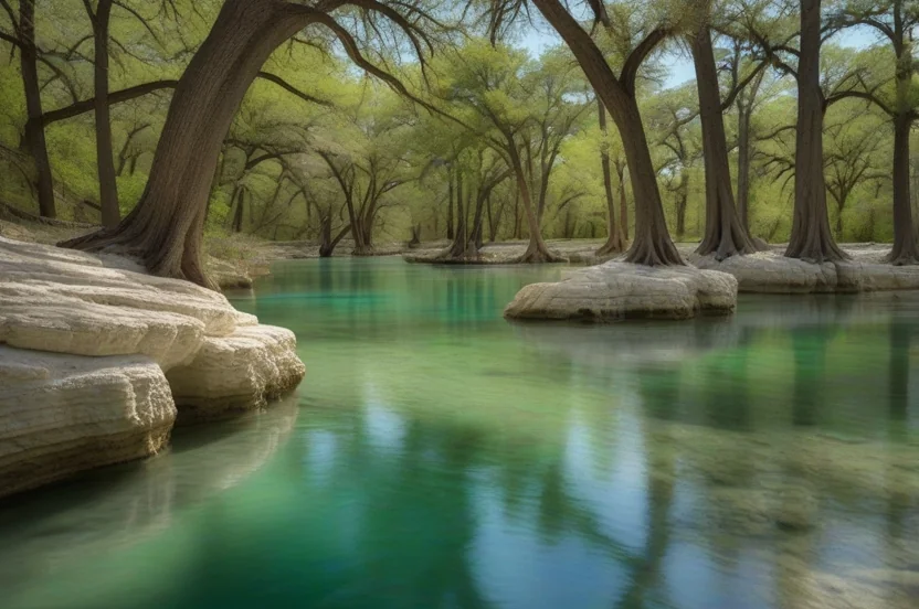
Rivers of the Edwards Plateau include:
- Guadalupe River: Crystal-clear Hill Country icon
- Llano River: Runs through the Llano Uplift granite region
- Pedernales River: LBJ’s beloved river near Johnson City
- Frio River: Spring-fed “cold” river of the western Hill Country
- Nueces River: Major western plateau river
- Devils River: One of Texas’s most pristine waterways
Native Plants of the Edwards Plateau
The Edwards Plateau supports a unique plant community adapted to thin, limestone-derived soils and semi-arid conditions. While less diverse than the Piney Woods, the Hill Country flora includes many species found only in this region.
Dominant Tree Species
Ashe Juniper (Juniperus ashei)
The Ashe Juniper (Juniperus ashei)—often incorrectly called “cedar”—is the defining tree of the modern Edwards Plateau. These aromatic evergreens have expanded dramatically since European settlement due to fire suppression and overgrazing.
Ashe junipers are either loved or hated. Ranchers consider them invasive brush that outcompetes grasses. Allergy sufferers dread “cedar fever” when the trees release clouds of pollen each winter. Yet Ashe juniper provides critical habitat for the endangered Golden-cheeked Warbler, which nests only in mature juniper-oak woodlands.
Plateau Live Oak (Quercus fusiformis)
The Plateau Live Oak (Quercus fusiformis)—also called the Texas Live Oak—is the iconic oak of the Hill Country. These beautiful evergreen oaks form the savanna woodlands that characterize much of the eastern plateau. Unlike their coastal cousins, plateau live oaks typically have smaller leaves and can tolerate the region’s drier conditions.
Other Notable Trees
- Texas Red Oak (Quercus buckleyi) – Brilliant fall color, especially at Lost Maples
- Lacey Oak (Quercus laceyi) – Blue-green leaves, endemic to Edwards Plateau
- Texas Ash (Fraxinus texensis) – Fall color along streams
- Pecan (Carya illinoinensis) – State tree, found along waterways
- Bald Cypress (Taxodium distichum) – Lines spring-fed streams
- Mexican Buckeye (Ungnadia speciosa) – Pink spring blooms
- Texas Madrone (Arbutus xalapensis) – Beautiful peeling bark, uncommon
KEY TAKEAWAY: The Lost Maples State Natural Area protects a relict population of Bigtooth Maples (Acer grandidentatum) that survived in these sheltered canyons since the last Ice Age. This isolated population, separated from maples in the Rocky Mountains by 500 miles, provides spectacular fall color each November—the southernmost fall foliage display in North America.
Wildflowers
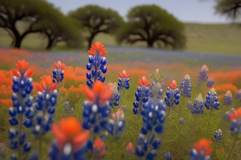
The Hill Country is legendary for spring wildflowers. The thin soils and open terrain create perfect conditions for spectacular displays.
- Texas Bluebonnet (Lupinus texensis) – State flower, peaks mid-April
- Indian Paintbrush (Castilleja indivisa) – Orange-red, often with bluebonnets
- Pink Evening Primrose (Oenothera speciosa) – Delicate pink blooms
- Texas Yellow Star (Lindheimera texana) – Bright yellow, early spring
- Wine Cup (Callirhoe involucrata) – Deep magenta ground cover
- Flame Acanthus (Anisacanthus quadrifidus var. wrightii) – Red tubular flowers, hummingbird magnet
- Blackfoot Daisy (Melampodium leucanthum) – White daisy, blooms repeatedly
- Cenizo (Leucophyllum frutescens) – “Barometer bush,” blooms after rain
PRO TIP: For the best wildflower viewing, visit between mid-March and late April. The Willow City Loop north of Fredericksburg and Highway 29 west of Llano offer spectacular displays. Timing varies with winter rainfall—wet winters produce better blooms.
Wildlife of the Edwards Plateau
The Edwards Plateau supports wildlife adapted to its semi-arid, rocky terrain. While lacking the diversity of the Piney Woods, the region provides critical habitat for several endangered species found nowhere else.
Endangered Birds
Golden-cheeked Warbler (Setophaga chrysoparia)
The Golden-cheeked Warbler (Setophaga chrysoparia) is the only bird species that nests exclusively in Texas. This beautiful black-and-yellow songbird breeds only in the mature Ashe juniper-oak woodlands of the Edwards Plateau before migrating to Central American highlands for winter.
Golden-cheeked Warblers are federally endangered, threatened primarily by habitat loss as Austin and San Antonio expand into the Hill Country. The birds require mature juniper for their unique bark-strip nests—they literally cannot reproduce without old-growth Ashe juniper forests.
Best places to see: Balcones Canyonlands NWR, Friedrich Wilderness Park, Lost Maples SNA
Black-capped Vireo (Vireo atricapilla)
The Black-capped Vireo (Vireo atricapilla) is another Hill Country specialist, nesting in low, shrubby oak habitats called “shin oak mottes.” This small songbird was federally endangered until 2018, when intensive conservation efforts allowed its delisting—a rare success story.
Best places to see: Balcones Canyonlands NWR, Kerr Wildlife Management Area
Mammals
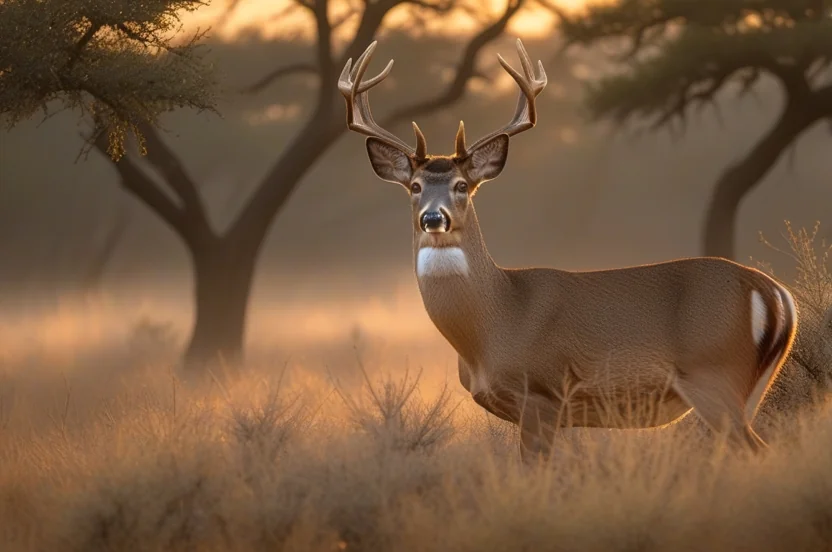
White-tailed Deer (Odocoileus virginianus)
The White-tailed Deer (Odocoileus virginianus) reaches its highest densities anywhere on the Edwards Plateau. The Hill Country is often called the “deer capital of North America,” with an estimated 4 million deer—more than any comparably sized region in the world.
Other Mammals
- Axis Deer (Axis axis) – Exotic from India, now widespread
- Feral Hog (Sus scrofa) – Destructive invasive, abundant
- Nine-banded Armadillo (Dasypus novemcinctus) – Common
- Ringtail (Bassariscus astutus) – Nocturnal, catlike relative of raccoon
- Gray Fox (Urocyon cinereoargenteus) – Climbs trees, common
- Western Diamondback Rattlesnake (Crotalus atrox) – Watch your step!
- Texas Horned Lizard (Phrynosoma cornutum) – State reptile, declining
KEY TAKEAWAY: The Edwards Plateau supports an unusual number of exotic mammals—axis deer, blackbuck antelope, fallow deer, sika deer, and more—introduced to Hill Country ranches for hunting. These exotic populations now total in the hundreds of thousands and compete with native wildlife for resources.
Best Places to Explore the Edwards Plateau
The Edwards Plateau offers outstanding public lands, from state parks to wildlife refuges. Here are the best places to experience Hill Country nature.
Enchanted Rock State Natural Area
Location: Fredericksburg (18 miles north)
Size: 1,644 acres
Best for: Hiking, rock climbing, stargazing
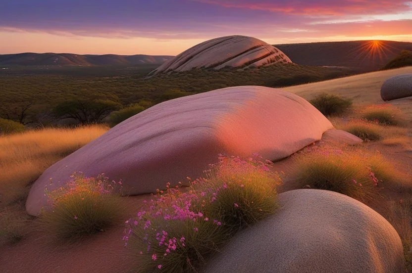
Rising 425 feet above the surrounding terrain, Enchanted Rock is a massive pink granite dome—one of the largest batholiths in the United States. This ancient rock, part of the Llano Uplift, is over 1 billion years old, making it among the oldest exposed rock in Texas.
Highlights:
- Summit hike with 360-degree Hill Country views
- Excellent rock climbing routes
- Dark sky stargazing programs
- Spring wildflowers on the dome
Visitor Info: Reservations required on weekends and holidays; the park reaches capacity quickly.
Lost Maples State Natural Area
Location: Vanderpool (5 miles north)
Size: 2,174 acres
Best for: Fall foliage, hiking, birding
This canyon refuge protects a relict forest of Bigtooth Maples left behind after the last Ice Age. The fall color here—typically peaking late October through mid-November—is the best in Texas and draws crowds each year.
Highlights:
- 11 miles of trails through maple canyons
- Best fall color in Texas (late October-November)
- Excellent birding for Golden-cheeked Warblers (spring)
- Old-growth Texas oaks and Lacey oaks
Garner State Park
Location: Concan
Size: 1,774 acres
Best for: Swimming, camping, family recreation
The Frio River cuts through this beloved park, creating the spring-fed swimming holes that make it one of Texas’s most popular state parks. The river maintains temperatures around 68°F even in summer—refreshingly cold.
Highlights:
- Crystal-clear Frio River swimming
- Jukebox dancing tradition at pavilion
- Old Baldy summit hike
- Family camping
Pedernales Falls State Park
Location: Johnson City (9 miles east)
Size: 5,212 acres
Best for: Hiking, photography, river access
The Pedernales River tumbles over dramatic limestone ledges here, creating the “falls” that give the park its name. LBJ once swam in these waters, and the park preserves classic Hill Country terrain.
PRO TIP: For a taste of Hill Country nature close to Austin or San Antonio, try Friedrich Wilderness Park (San Antonio) or Barton Creek Greenbelt (Austin). Both offer good habitat for Golden-cheeked Warblers in spring and easy access for shorter visits.
Conservation and Threats
The Edwards Plateau faces significant conservation challenges, primarily driven by the explosive growth of Austin and San Antonio and changes in land use across the region.
Current Threats
Urban Sprawl
The Austin-San Antonio corridor is one of the fastest-growing regions in the United States. As cities expand into the Hill Country, habitat for endangered species disappears beneath subdivisions, and impervious cover threatens groundwater recharge.
Groundwater Depletion
The Edwards Aquifer is being pumped faster than it recharges in many areas. During droughts, spring flows decrease dramatically, threatening the unique aquatic species that depend on constant spring discharge.
How You Can Help
- Support land conservation through donations to Hill Country Conservancy, Nature Conservancy, or local land trusts
- Practice responsible recreation by staying on trails and leaving no trace
- Reduce water usage to protect aquifer levels
- Choose native plants for landscaping to support local wildlife
- Report poaching and dumping to Texas Parks & Wildlife
KEY TAKEAWAY: The Edwards Plateau is at a crossroads. The next two decades will determine whether the Hill Country retains its natural character or becomes an endless suburban sprawl. Every acre protected now becomes more valuable as development pressure intensifies.
Frequently Asked Questions
What counties are in the Edwards Plateau?
The Edwards Plateau covers all or part of over 40 Texas counties, including Travis (Austin), Bexar (San Antonio), Gillespie (Fredericksburg), Kerr (Kerrville), Kendall (Boerne), Blanco (Johnson City), Hays, Comal, Uvalde, Val Verde, and many others extending westward to the Pecos River.
What is the Edwards Plateau known for?
The Edwards Plateau is known for its scenic Hill Country landscapes, spring-fed rivers, wildflower displays, the Edwards Aquifer, abundant white-tailed deer, limestone caves, and as the only nesting habitat for the endangered Golden-cheeked Warbler. It’s also Texas’s wine country and a major tourism destination.
What wildlife can you see on the Edwards Plateau?
Common wildlife includes white-tailed deer (very abundant), wild turkey, armadillos, roadrunners, various songbirds, and reptiles. Notable species include the endangered Golden-cheeked Warbler and Black-capped Vireo, the declining Texas Horned Lizard, and rare cave fauna like the Texas Blind Salamander.
What is the best time to visit the Hill Country?
Spring (mid-March through May) offers the best combination of wildflowers, comfortable temperatures, and wildlife viewing. Fall (October-November) provides pleasant weather and fall color at Lost Maples. Summer is hot but ideal for river swimming. Winter is mild but brings cedar pollen.
What caves can you visit on the Edwards Plateau?
Public show caves include Natural Bridge Caverns (largest), Longhorn Cavern State Park, Cascade Caverns, Cave Without a Name, Inner Space Cavern, and Wonder Cave. Many other caves exist but are on private land or protected for endangered species.
How is the Edwards Plateau different from the Texas Piney Woods?
The Edwards Plateau is semi-arid with limestone soils, dominated by juniper and live oak, while the Piney Woods is humid with sandy acidic soils and pine forests. The Edwards Plateau receives 15-34 inches of rain annually compared to 40-56 inches in the Piney Woods. The two ecoregions share almost no plant or animal species.
Are there endangered species on the Edwards Plateau?
Yes. The Golden-cheeked Warbler (bird), Texas Blind Salamander (cave species), and several cave invertebrates are federally endangered. The Black-capped Vireo was recently delisted thanks to successful conservation. Many cave species remain candidates for protection.
Explore the Edwards Plateau
The Edwards Plateau offers a quintessential Texas experience—rolling hills dotted with live oaks, clear spring-fed rivers, fields of wildflowers, and the kind of wide-open spaces that define the American West. Yet beneath this scenic surface lies a fragile world of endangered songbirds, ancient caves, and an aquifer that millions depend upon.
Whether you’re swimming the crystal waters of the Frio River, hiking to the summit of Enchanted Rock at sunrise, or listening for the distinctive song of a Golden-cheeked Warbler in a juniper canyon, the Hill Country rewards careful exploration.
Ready to explore? Start with Enchanted Rock for iconic Hill Country scenery, or visit Lost Maples for fall color. And remember: by supporting conservation efforts and practicing responsible recreation, you help ensure these landscapes remain wild for future generations.
Related Guides: